Flag of Mauritania
الجمهورية الإسلامية الموريتانية
- al-Jumhūrīyah al-Islāmīyah al-Mūrītānīyah
- République islamique de Mauritanie (French)
- Islamic Republic of Mauritania (English)
- Capital » Nouakchott
Facts
- 4.42 million (2017)
- Major languages: Arabic, Hassaniya
- Foreign languages: French
- Muslin country
- Currency: 1 Ouguiya (MRO) = 5 Khoums
- XE Profile
- Exchange Rate » OANDA
- Electricity: 220 Volt / 50 Hertz AC
Geography
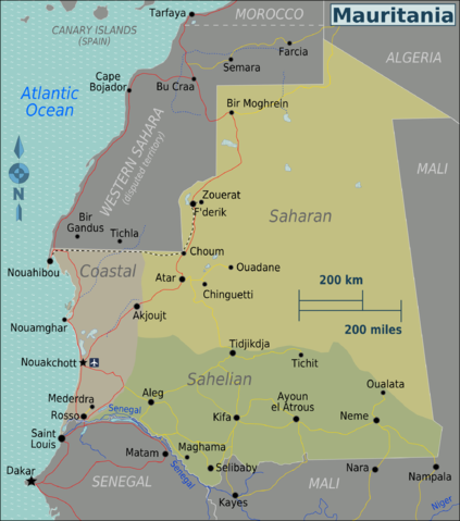
- Mauritania is a country in Northwest Africa.
- It is bordered by the Atlantic Ocean to the west, Western Sahara to the north and northwest, Algeria to the northeast, Mali to the east and southeast, and Senegal to the southwest.
Maps
Adventure
- Check Border Crossing info at Sahara Overland
- Visas may be issued at airports and the Moroccan, Algerian, Senegalese (Rosso) and some Mali borders. Check before as info is a few years old.
Points of Interest
- Richat Structure
- Also called Guelb er Richât, the “Eye of Africa”, or “Eye of the Sahara” is a prominent circular feature in the Sahara’s Adrar Plateau, near Ouadane, west–central Mauritania.
- Banc d’Arguin National Park
- This World Heritage Site is a major breeding site for migratory birds, including flamingos, broad-billed sandpipers, pelicans and terns.
Adventure Overland
- It is not safe to go solo off into the desert starting in April due to the heat. Altar locals often move to the coast to escape the dry heat in April. Better months are between November and April.
- There is a sort of 20 km wide no-man land area between Mauritania and Western Sahara where it is very dangerous – land mines – to venture off the travel portion of the road. Stay on the well marked track.
- Sahara Overland
Notes
- Mauritania is the least developed country in northwester Africa
- Extremist groups pose a danger to travellers
Government Travel Advice
Media
Resources
This page was updated April 15, 2023

