
Flag of Guyana
Co-operative Republic of Guyana
- Capital » Georgetown
- also the largest city in Guyana
Facts
- Population » 795,400
- Languages » English, indigenous languages, Creole, Hindi, Urdu
- Religions » Christianity, Hinduism, Islam
- Life expectancy » 67 years (men) 73 years (women)
- Currency » Guyanese dollar (GYD)
- denoted as $ or G$
Geography
- Area » 214,969 sq km (83,000 sq miles)
- Guyana is the third-smallest country in South America.
- Most of the country is covered in tropical rainforest
- At over 87% forest cover, Guyana is one of the most heavily forested countries in South America.
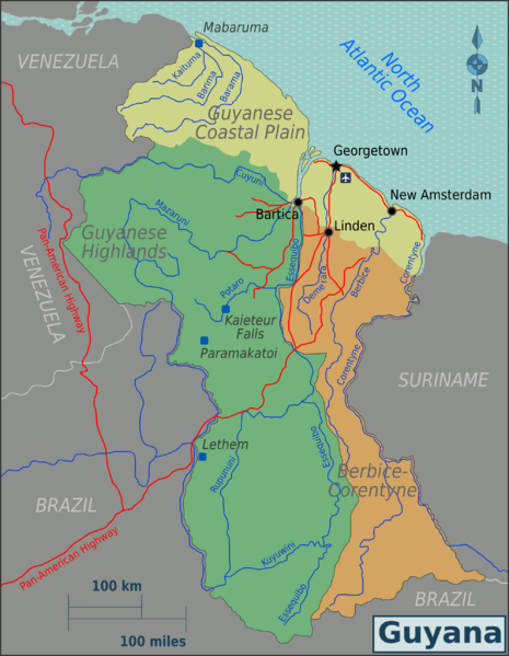
Map of Guyana (Source » Wikimedia)
Maps
Visa
- Canadians can stay visa-free for up to 3 months
Tourism
- Guyana is still a relatively untapped destination for tourists
- Stabroek Market is a quaint market in Georgetown.
- Note » Muggings are possible.
Adventures
- Kaieteur National Park
- An Amazonian experience for lovers of the jungle
- Camping is not permitted in the park. Instead book at Kaieteur National Park Guesthouses.
- Kaieteur Falls (Bradt)is Guyana’s tourism poster child
- The waterfall is the largest single drop fall on the planet. Though there are taller waterfalls, there is no other that matches its combination of height and water volume, making it arguably the world’s most powerful waterfall.
- Iwokrama Forest (Website | Bradt)
- Iwokrama International Centre for Rainforest Conservation and Development
- Wikivoyage
Overland
- Drive on the left side of the road
- Travel to and around Guyana’s interior is much easier during the dry season
- Asphalt on roads along the coastline and from Georgetown south to Linden.
- Guyana has road access to Suriname to the east and Brazil to the south.
- Access to Brazil is via Lethem
- Lethem is the border town located between Brazil and Guyana.
- The road from Georgetown to Lethem is long (547 km/340 mi), bumpy, full of pot holes, and very difficult in rainy season! Petrol also available in Linden.
- The road between Georgetown to Linden is an asphalt
- Linden to Lethem is some 445KM of bush trail
- The main unpaved road that runs from Linden to Lethem is very difficult during rain season, impassable without a reliable 4WD
- Access to Brazil is via Lethem
- There are no direct roads between Venezuela and Guyana.
- To get to Venezuela drive up to Santa Elena from Lethem (in Brazil the road is mostly good).
Climate
- Guyana’s climate is tropical with the hot, humid conditions moderated by trade winds, all year.
- There are two distinct rainy seasons: May to mid-August and mid-November to mid-January.
- The heavy rains, primary wet season, runs from May to July (or August).
- During these months huge swathes of the savannas flood and rivers can rise some 30ft above their dry season levels.
- Flash floods are a constant threat during these rainy seasons.
- For low water levels and to see caiman and otters, February to April and August to November are the best months. From late December to late January is the secondary rainy season.
- The heavy rains, primary wet season, runs from May to July (or August).
- The dry season offers little relief from the heat
- Insects should be expected year-round
Notes
- Sandwiched between Venezuela and Suriname, the former British colony of Guyana is the only English-speaking country in South America.
- Guyana’s economy has been undergoing a transformation since the discovery of crude oil in 2015 and commercial drilling in 2019.
Security
- There are relatively high rates of violent crime such as armed robbery, carjacking, shootings, kidnapping, and assault in Guyana, particularly in urban areas. (September 2023)
- Piracy remains a threat in the coastal waters off Guyana. (International Maritime Bureau’s piracy report)
Travel advisories
News
Resources
This page was updated September 19, 2023